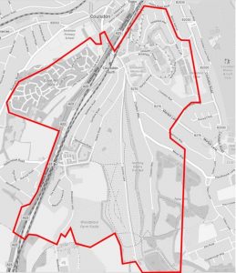
 The area covered by ECRA is mostly bounded by the main Brighton Road from Marlpit Lane, to the Borough boundary at Garden Close, crossing Farthing Downs taking in parts of Woodplace Lane, Ditches Lane, Chaldon Way, Mead Way, Bradmore Way, Marlpit Lane to Bradmore Ponds, Stoneyfield Road, to Coulsdon Woods to include Deepfield Way and back to Marlpit Lane.
Cane Hill Park is covered by ECRA, but also has a Resident’s Association, CHiPRA, dealing with particular issues relevant to Cane Hill.
Since the Ward Boundary Changes in May 2018 some of the ECRA area is in Coulsdon Town Ward and some in Old Coulsdon Ward.
Coulsdon Town Centre, Farthing Downs & Happy Valley
In addition to the core area, ECRA and its residents are interested in surrounding areas, particularly the Town Centre, Farthing Downs and Happy Valley.
The Dutch Village
Wilhelmina and The Netherlands roads form distinctive estate known as The Dutch Village, which is a Local Area of Special Character. It was designed by the Dutch architect Wouter Hamdorff as a ‘modern Dutch garden village’ in late 1930’s.